Winter Starts Off With a Florida Freeze
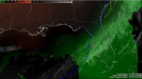
A moderately strong line of thunderstorms is pushing through southwest and southern Florida at this hour, and cooler air is on its way to the sunshine state. The line of thunderstorms is now separated from the cold front, which is still situated from Cedar Key to Jacksonville Beach. I think the front will attempt to catch up before the line of thunderstorms pushes into the Florida Straights before 8am. Before all is said and done, much of the state will have picked up a third of an inch of rain. A few lucky spots in the panhandle received more than an inch of rain since yesterday. Severe weather was scattered with only one tornadic report in the Big Bend and numerous severe wind readings in the panhandle. As expected winds were the main issue today as the jet stream passed by and then became more zonal by late afternoon. Winds continue to be around 40 mph in the strongest storms as they pass through. As the squall line passed through winds gusted to 46 mph.
The Front: The front should hold together all the way through the Florida Keys with a solid or semi-broken line of thunderstorms, and will be reaching extreme south Florida between 7-9am this morning. All severe weather has come to an end and no more extreme winds are expected. The front is accelerating and should catch up with the thunderstorms before departure into the Caribbean.
Cooler/Drier Air: Drier air has begun working into northern Florida as depicted below in the brownish-red colors. Dew points in the panhandle range from the low 40s in Pensacola to the upper 50s where the dry air is just being felt behind the front in Cross City. Dew points elsewhere in Florida are bordering on uncomfortable in the upper 50s to near 70. Much of that dampness and uncomfortability will all be coming to an end tomorrow as the moisture drain is turned on high.
Tomorrow will be an upside down day temperatures wise for most of the state with highs occurring either now or before sunset instead of mid afternoon. From there, heat will be pulled southward and temperatures will drop through Friday night.
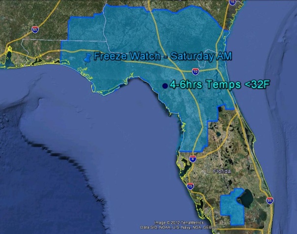
With the drier air in place and high pressure moving in, Friday night and Saturday morning will feature some of the coolest air of the year. Temperatures will fall into the 20s and 30s in north Florida. The freezing line could plunge as far south as interior central Florida. Such places as Leesburg and Dade City may get down to freezing overnight on Friday night and possibly again on Saturday night. Friday night will likely feel the coolest of the two nights because of the wind chill factor that will be in play. Meteorologists use the term advective cooling for this type of situation, a situation in which wind brings in cold air from somewhere else. More on advective cooling can be found to the right in tonight’s Meteorology Mumbo. The wind will be between 10-20 mph across the state tomorrow night, which will make feels like temperatures anywhere from 5-10 degrees cooler than the actual temperature. In interior north Florida, feels like temperatures may be as low as 20 degrees in some spots where there are no physical obstructions such as buildings and trees. I expect a wind chill advisory may have to be issued for a good chunk of the state. I also believe that the freeze watch, depicted below, may have to be expanded to include the outer suburbs of Orlando and the interior space coast. The Miami WFO has already went ahead and issued freeze watches for interior southern Florida, and I expect these to be brought northward.
Saturday will be a cool day for most with highs only getting into the 50s and 60s. The bright side to this forecast is that winds will be coming down throughout the day and will come to a calm overnight on Saturday night. The bad news is that after dark on Saturday the temperatures will plunge! Winds help keep the warm temperatures at the surface, and without wind the heat escapes to space. I expect similar temperatures to Friday night in most locations, however I think the temperatures to be a bit cooler in southwest Florida.
Special Report: Winter:
You’ve probably heard that today is the first day of winter, but what does that actually mean? Although tomorrow’s forecast says otherwise, it usually does not mean cooler temperatures are instantly guaranteed. It is purely an astronomical designation. In astronomy, winter solstice is the time when the sun’s rays are pointed at the farthest southern point on the Earth, which is called the Tropic of Capricorn. This winter solstice is a bit out of the ordinary in the fact that it happens at 6:12am on the east coast, which is the earliest time of the day that it has happened since 1896! This day is also the shortest day of the year. From here on out the days get longer, which is good news for most of us.
Enjoy the shortest day of the year and the first day of Winter!!
Posted on Friday, December 21st, 2012, in Florida Weather, Winter Weather. Bookmark the permalink. Leave a comment.


Leave a comment
Comments 0